Under the watchful eyes of Pacific Open Water Swim Co.
September 8th 2021
~5 miles, water temp 63F-65F (17C/18C)
I was wearing a sleeveless wetsuit, two swim caps, tinted Aqua Sphere goggles and ear plugs.
liberal application of Body Glide and Vaseline.
 |
| The swim map (Coros watch app). |
The meeting time was set for 5:45AM - there was a bit of delay and we finally made our way to Angel Island and started the swim at 6:50AM.
Swimmer drop was at Point Campbell, the west end of China Cove and I headed east for a clockwise swim around the island. It started off well - the water was choppy but not too cold. I was heading east directly into the rising sun. The views were stunning - the sun's orange glitter path was really mesmerizing. You could see the shimmering shades of orange and yellow underwater.
 |
| While I painted this based on one of Bryan's photographs from a Tahoe swim. The sunrise looked just as stunning here in the Bay. |
I kept the sun dead straight ahead until we rounded Point Simpton and headed South/South East. There were patches of seaweed that brushed against me and shook me out of my tranquility. The Bay waters are wild and choppy and home to many creatures, I was happy it was only seaweed. Land sighting marks were difficult to find at times due to the waves - but I kept the sun to my left and got glimpses of the SalesForce tower every now and then. Bryan (the pilot) shouted out that I should aim for Alcatraz Island (heading south) and go wide of Point Blunt Rock. The next sighting point was the south tower of the Golden Gate Bridge, I think the idea was to move out of the eddies created by the Blunt Rock outcrop.
 |
| Sighting direction (From your right to left) South to the city. Aiming for Alcatraz, sighting south tower of GGB, sighting the Sausalito houses. |
I ended up swimming past the Green Buoy off Point Blunt and thought I may have gone too far into the shipping lane! But I knew I was in safe hands. A bit about the pilots on these open swims - they are amazing! Super multitaskers - they had to continuously monitor my progress, check in with the Coast Guard for ship/boat traffic, arrange my feeds and keep a track of the currents! Bryan was the sole pilot on this swim and this was my 5th swim in the Bay with him. Absolute Rockstar!
The pilot signaled and asked me to aim for the houses on Sausalito (I was now heading West) - this was the final westward swim before turning into Racoon Strait. I made that right turn and thought I was heading west towards Sausalito. But for some reason I kept drifting right and swimming more northwest than west (not sure if it was the current pushing me or a stronger right arm pull). That drift cost me some time and Bryan asked me to aim for the rocks just before Perles Beach and go in as close as possible (shallow waters have milder currents). This was to get me out of the flood current that had kicked up a few gears. As I got close to the rocks - I got a bit nervous - I've been cut by sharp barnacled rocks before - so I tried to swim out a bit and away from the rocks! This is where an exasperated Bryan probably realized that I was not going to get out of that flood (he wanted me to go close to the shore - 10 feet from the rocks - as close as possible in order to make that right turn for the home stretch). So after a few more calls of 'swim to the rocks, swim!!'...he pulled the plug and asked me to get on the boat as I could not outswim the flood current. Ah well! :)
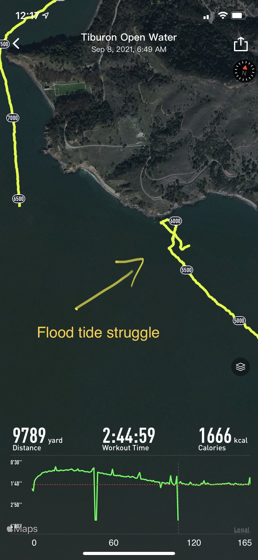 |
| Another 100 yards and I'd have made the turn. But I kept moving away from the shore. That is the power of the flood current. |
He repositioned me to the west of Perles Beach and I made the final portion of the swim around Point Stuart and headed Northeast into Racoon Strait for the home stretch. All in all a 9,200 to 9,300 yard swim (about 5.2miles).
I enjoy swimming in the Bay and even after being repositioned I was happy to jump in and finish the remaining 3,300 yards to get an almost full loop around the island. :)
 |
| Timing. The yellow circled 500 yard section was where I was on the boat being repositioned. |
Feed stops were every 45 mins. That worked out well. The first feed included a gel and my Gatorade drink. The only problem was that the feed was handed out to me in a paddle net and by the time I finished the gel and sipping the drink I had drifted 15-20 yards away from the boat. Swimming back with a bottle in my hand to put it back in the net was a bit challenging. The next feed was the typical bottle tied to a rope - it was easier to drink, drop the bottle in the water and swim - Bryan pulled the bottle back in - that worked much better. Total calorie intake was about 350 total about 150/170 per hour.(sports drink + one Gu Gel).
What went well:
1) I had bandaged all the hotspots to stop friction burns. My training swims had given me an idea as to where I'd get wetsuit friction rash. Being a runner, taping hotspots that become blisters is a common experience that helps across sports.
2) Knowing that the swim would be about 3 hours long, my longest training swim was about 2.5 hours. That worked out well. I was not fatigued at the end.
3) Swimming throughout the year in Santa Cruz made me well acclimated to the cold water.
4) Having done a lot of open water swims all year made me comfortable with the chop and wave action of the bay. I had done 4 prior Bay swims with Pacific Open Water Swim Co this year. 3 Alcatraz crossings and a 90 mins swim along the coast of Tiburon.
5) Sighting was generally fine as long as I had the sun as reference during the rough spots and then it being a clear day all the other sighting points were clearly visible. Bryan pointing the way at other times.
6) We went clockwise around Angel Island - which worked for me as the boat was on my left most of the way - I breathe on the left.
7) Heart Rate was pretty steady as I kept the effort at a reasonable level.
8) I've racked up about 150+ miles of swimming this year (pool and open water).
Things I could improve on:
1) Need to work on getting faster. 1:45/100 yards to 1:50/100 yards in open water. Longer pull buoy sessions add more paddle work. Strengthen arms and refine my pull.
2) I need to ask more questions prior to the swim start. Maybe carry a printout of the map for a more visual depiction of what to expect. Where to expect the tide/current to switch. What sections need to be faster, wider, etc.
3) Need to understand the currents movement at the start. I knew that low tide was at 7:12am - so had I started at 6:30am I may have made the westward swim section just before the flood stepped up a gear.
4) Work on feeding during training.
5) Need to do a blind swim test to check how prominent my right drift has become.
6) Figure out how to combat saltwater tongue. I've heard of coating it with coconut oil - may give it a shot on the next 3+ hour swim in the Bay. A day later and the tongue is still sore.
Notes:
The above pace is not really indicative of my actual swim pace. Most Bay swims are 'current assisted' or as they say - you 'ride the tide'. So they will be much much faster than normal. And on the other hand, if you mistime the tide you can get stuck against the flood current (or ebb current) and end up swimming in one place or even pushed backwards.
Definitions and a wonderful tutorial from NOAA:
Tides: Tides are the rise and fall of water levels.
Current: Currents are horizontal flow of water.
Here are some visuals on the tides/currents in the Bay.
If you imagine the San Francisco Bay as a big lake that drains out and fill up every ~6 hours - as the tide goes out (ebbs) you get a strong ebb current (where the water is leaving the Bay and heading out under the Golden Gate Bridge into the Pacific). As the tide comes in (flood) there is a very strong flood current coming in from the Pacific into the SF Bay. These are almost like rivers flowing in and out.
In the San Francisco Bay, ebb currents are stronger than flood currents because of the river water flowing into the bay.
Eddies and counter currents: Around the islands (Angel, Alcatraz, Treasure etc.) and the coast there are counter currents and back-eddies and swirling eddies that are caused by shallower water, obstructions to water flow (natural or human made). As flowing water hits an obstacle such as an island, pier, underwater mounds or an outcropping it diverts the flow and causes counter currents that flow in the opposite direction of the main current or causing eddies where the water swirls around in circles. Typically, the main currents are stronger in deeper water than in shallow waters near the shores.


No comments:
Post a Comment